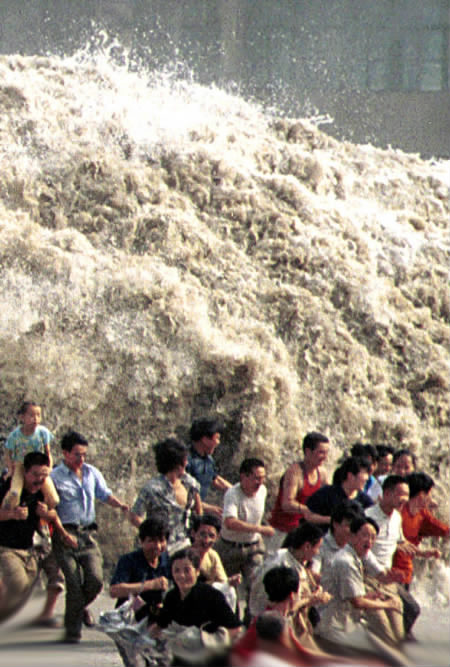
The word "tsunami" comes from the Japanese words tsu (harbor) and nami (waves). A tsunami is a wave or series of waves in the ocean that can be hundreds of miles long and have been known to reach heights of up to 34 ft (10.5 m). The waves can travel as fast sa commercial jet. The massive tsunami on 26th December, 2004 traveled 375 miles (600 km) in 75 minutes. around 300 mph (480 kph). The waves are capable of causing huge damage along coastal lands.
The natural occurrences capable of causing a tsunami are referred to as tsunamigenic events. In addition to earthquakes and volcanism, submarine volcanoes and submarine landslides are two less likely tsunamigenic events. Mostly these events occur alongside major earthquakes, adding to the overall power of a tsunami. They work the same as the earthquake in that the extreme upward release of energy from the event affects the overlying water.
The greatest earthquake in 40 years occurred on Sunday, 26th December 2004, about 150 kilometers off the west coast of northern Sumatra Island in Indonesia. It resulted in a disastrous tsunami that destroyed 11 countries bordering the Indian Ocean.
Origin Time and Epicenter
The great earthquake occurred on Sunday, 26 December 2004, at 00:58:50 UTC (6:58:50 a.m. local time). The epicenter was at 3.298 N, 95.779 E and its focal depth was very shallow (much less than 33 km - possibly about 10km)
Magnitude and Energy Release
The quake was widely felt in Sumatra, Singapore, Thailand, Myanmar, the Nicobar and Andaman Islands, Malaysia, Bangladesh and India.
According to the U.S. Geological Survey (USGS NEIC (WDCS-D)), the moment magnitude of the earthquake was 9. An earthquake of such magnitude would make it the fourth largest in the world since 1900 - and the largest since the 1964 Alaska earthquake.
However, on subsequent analysis of additional seismograms from around the world, scientists from Northwestern University determined the its magnitude to be 9.3. Therefore, the calculated energy release was 1.13 X 10 (raised to the 30 power) dynes-cm. The revised estimate makes this earthquake to be the second largest ever instrumentally recorded. The largest earthquake ever recorded, which measured 9.5, was in Chile on May 22, 1960.
 Tectonic Setting
The region where the great earthquake occurred, marks the seismic boundary formed by the movement of the Indo-Australian plate as it collides with the Burma subplate, which is part of the Eurasian plate. However the two plates have separated many million years ago and that the Australian plate is rotating in a counterclockwise direction, putting stress on the Indian plate, according to recent studies reported in the Earth and Planetary Science Letters (vol 133).
Over a period of million years, the India tectonic plate moved in a north/northeast direction, to collide with the Eurasian tectonic plate and hence the Himalayan mountains were formed. Because of this migration and collision with the Eurasian and the Australian tectonic plates, the Indian plate's eastern boundary is characterized by extensive faulting and large earthquakes, forming diffuse zone of seismicity and deformation.
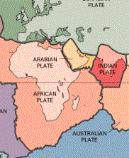
The triple point junction of three tectonic plates formed the epicenter for the earthquake that occurred on 26th December.
Previous major earthquakes have occurred north, in the Andaman Sea and South along the Sumatra, Java and Sunda; sections of one of the earth's greatest fault zones, a subduction zone known as the Sunda Trench. This great trench extends for about 3,400 miles (5,500 kms) from Myanmar (Burma) south past Sumatra and Java and east toward Australia and the Lesser Sunda Islands, ending up near Timor. The volcanoes of Krakatau, Tambora and Toba, well known for their violent eruptions, are byproducts of such tectonic interactions.
The Sunda Trench alongwith the Sumatra fault is responsible for high seismic activity on the Island of Sumatra. The fault extends along the entire length of the island.
The Burma plate encompasses the northwest portion of the island of Sumatra Andaman and the Nicobar Islands. A divergent boundary separates the Burma plate from the Sunda plate.
More specifically, in the region off the west coast of northern Sumatra, the India plate is moving in a northeastward direction at about 5 to 5.5 cm per year relative to the Burma plate.
Aftershocks
As of 1 January, 2005, there were about 84 aftershocks with magnitudes ranging from 5.0 to 7.0 in the region of Northern Sumatra and the Nicobar and Andaman Islands. Twenty six (26) of these - including the largest- occurred on 26 December 2004itself. The aftershocks are expected to continue for several weeks and months. Some of the major aftershocks have occurred in the vicinity of the epicenter of a past earthquake which had occurred on 26 June 1941 and some in the area near the Nicobar Islands where the 1881 earthquake had occurred.
The distribution of afteshocks suggests that the earthquake resulted by the sudden slip of these two plates and that there was a slip as well as an upward thrust of the Burma plate along this boundary.
No comments:
Post a Comment